The new Ouse Washes LP Website is Live!!

Today is a very exciting day as we are finally able to share our new website with the world!

logos


Website screen capture home page 18 12 2014

Please pass on the message to others: www.ousewashes.org.uk


This website is intended to be a ‘one-stop shop’ for local people and visitors to explore the Ouse Washes Landscape:

  • Explore the Ouse Washes LP area’s tourist attractions, nature reserves and museums in more detail through our interactive Explore map;
  • Find out what’s going on in the area through our What’s on section;
  • Find out how you can get involved through our projects, events and our volunteering options in our Get Involved section
  • Find out what makes the Ouse Washes LP area special, by reading through our Discover section;
  • The Ouse News is our old WordPress blog incorporated in this new website – keep up to date of all new events, project development and information about the area though this newsreel
  • And a lot more – go on, find out for yourself!


Do let us know what you think about the new website – we want this to be useful for you, so please help us make things better – drop us a line through the Contact section.


Happy reading!


Press release: Press release_New website for Ouse Washes Landscape now live!

Denver Sluice Complex, one of the key hubs in the Ouse Washes Landscape area. Image: Kite Aerial Photography by Bill Blake Heritage Documentation

Denver Sluice Complex, one of the key hubs in the Ouse Washes Landscape area. Image: Kite Aerial Photography by Bill Blake Heritage Documentation


River Basin Management Plan

Have your input in the River Basin Management Plans for your area – workshops planned for 11, 16, 17 and 18 December for the Middle Level, Old Bedford, Ouse, Cam and NW Norfolk catchment areas:

Water Care Partnership

The Water Framework Directive is the main driver of improvements to water quality within Europe and consists of 6 yearly cycles of planning and delivery, in England these plans are the responsibility of the Environment Agency.

The first planning and delivery cycle began in 2009 and the Environment Agency has produced their draft River Basin Management Plans for the next cycle, which will begin in 2015. This plan is currently available for consultation and the draft plan can be found at https://consult.environment-agency.gov.uk/portal/ho/wfd/draft_plans/consult.

To help you do this the Environment Agency is holding a series of workshops over the next few months.  The first workshop will look at the Old Bedford and Middle Level Management Catchment on 11 December 2014, 9.30 – 1.00pm at the Environment Agency’s Denver Complex (Sluice Road, Denver, Downham Market, PE38 0EG) and you are cordially invited to come along.

In this first series of workshops the Environment…

View original post 226 more words

Impressions of the Ouse Washes LP conference


logosWe had a fantastic day last week in the Corn Exchange in St Ives. This excellent venue was the scene for the first annual conference for the Ouse Washes Landscape Partnership scheme. With a range of speakers, 112 attendees – representing over 64 organisations – and 20 exhibitors on the day we were off to a good start.

This conference, ‘Conservation, Farming, Flooding: our Natural Landscape?’ – the first in a series of three taking place annually – explored the natural landscape of the Ouse Washes Landscape Partnership area. The conference aimed to provide attendees with an overview of future management challenges including issues around biodiversity value, wetland habitat creation, farming challenges, water management and flood relief.

DSC_4849

Full house in the St Ives Corn Exchange. Image: NorthLight Media, for OWLP

A range of speakers from several key organisations (Natural England; RSPB; National Farmers’ Union; Environment Agency; and a consultant botanist who has carried out work for the OWLP scheme) provided for a rounded view of the central theme of the day.

This was followed by lively discussions focusing on the question which priorities  Ouse Washes Partnership need to set for this important landscape to ensure a sustainable future for this landscape. By bringing together local people and a range of partner organisations with a range of land-use interests we have encouraged stimulating debate and helped promote a wider appreciation and understanding of the challenges of living and working in this ever-changing landscape.

DSCN0086

Impression of conference. Image: Cambridgeshire ACRE

We have had a lot of good feedback, with the vast majority of people I have spoken to or received feedback from finding the day very enjoyable, highly informative, great for networking opportunities and with lots of food for thought as a result of stimulating round table discussions. In addition, there were 20 informative exhibitions from a range of organisations involved or associated with the partnership, great food, and an excellent walk to the nearby Holt island Nature Reserve at the end of the day.

Below are some images of the conference. If anyone, whether you attended or not, has any further questions, do drop me a line. Later down the line there will also be a report summarising the discussions on the day, and a short film will also be produced by NorthLight Media who took photographs and videos throughout the day – watch this space for further updates.

The results of the conference will feed into the ongoing legacy planning work of the Ouse Washes Landscape Partnership, with the recommendations and ideas generated helping the partnership’s work tremendously. Thank you all for your input!


Related posts and pages:


DSC_4844

The Mayor of St Ives starting the day. Image: NorthLight Media, for OWLP


DSC_4846

John Heading, farmer and IDB Chair, and OWLP Board member, Chairing the day. Image: NorthLight Media, for OWLP


DSC_4850

Alastair Burn, Natural England, setting the scene for the day, talking about the wetland vision for the Fens. Image: NorthLight Media, for OWLP

DSC_4854

Jonathan Graham, Consultant Botanist, providing data of new research on the biodiversity value of the fenland ditches in the OWLP area. Image: NorthLight Media, for OWLP

DSCN0101

Jonathan Graham, explaining the biodiversity value of the Fen ditches in the OWLP area. Image: Cambridgeshire ACRE


DSC_4855

Chris Hudson, RSPB, giving an understanding of the Ouse Fen nature reserve developments. Image: NorthLight Media, for OWLP

DSC_4861

Rob Wise, National Farmers’ Union, giving an overview of the Fen farmers’ challenges and opportunities. Image: NorthLight Media, for OWLP

DSC_4864

Peter Doktor, Environment Agency, explaining the reasons for the new habitat creation schemes next to the Ouse Washes. Image: NorthLight Media, for OWLP

DSCN0116

Peter Doktor, Environment Agency. Image: Cambridgeshire ACRE

_MG_1665

Round table discussions. Image: Bill Blake Heritage Documentation.

_MG_1688

Round table discussions. Image: Bill Blake Heritage Documentation.

DSC_4872

Round table discussions. Image: NorthLight Media, for OWLP.

DSC_4880

Round table discussions. Image: NorthLight Media, for OWLP.

DSC_4885

Round table discussions. Image: NorthLight Media, for OWLP.

DSC_4898

Round table discussions. Image: NorthLight Media, for OWLP.

DSC_4901

Round table discussions. Image: NorthLight Media, for OWLP.

DSC_4911

Round table discussions. Image: NorthLight Media, for OWLP.

DSCN0109

ADeC’s display of the three newly created murals. Image: Cambridgeshire ACRE

P1000974

ADeC’s display of the three newly created murals. Image: Cambridgeshire ACRE

DSCN0079

RSPB and Jonathan Graham’s displays. Image: Cambridgeshire ACRE

DSCN0106

Various displays in Corn Exchange. Image: Cambridgeshire ACRE

DSCN0078

ACE’s display. Image: Cambridgeshire ACRE

DSCN0072

Bill Blake’s display of KAP imagery. Image: Cambridgeshire ACRE

DSCN0065

Athene Communication’s display of the results of the ‘Opening up the Ouse Washes to All’ workshops.Image: Cambridgeshire ACRE

DSCN0066

Barn Owl Conservation Network’s display. Image: Cambridgeshire ACRE

DSCN0061

East Anglian Waterways Association’s display. Image: Cambridgeshire ACRE

DSCN0068

Green Light Trust’s display. Image: Cambridgeshire ACRE

DSCN0080

Fens Museum Partnership’s brand new animated film about the Ouse Washes. Image: Cambridgeshire ACRE

Capture

Guided walk on nearby Holt Island Nature Reserve, led by Ian Jackson. image: @TheBrecksBNG


Conservation, Farming, Flooding: Our Natural Landscape?

Logos

up the level from pymoor wide view Copyright Bill Blake Heritage Documentation

The Ouse Washes Landscape Partnership Annual Conference

Wednesday 19 November 2014  – 9am – 2pm

Anyone interested in the Ouse Washes area is invited to attend the first-ever Ouse Washes Landscape Partnership Conference which is taking place on Wednesday 19 November from 9am – 2pm at The Corn Exchange in St Ives, Cambridgeshire.

This conference – the first in a series of three, taking place annually – will explore the natural landscape of the Ouse Washes Landscape Partnership area. The conference aims to provide attendees with an overview of future management challenges including issues around landscape-scale conservation, biodiversity value, agricultural importance and flood relief. A background to wetland creation schemes in the area will be given through presentations with discussion facilitated in small groups regarding the future importance of the natural landscape.

The Ouse Washes landscape area has a multitude of different uses. It has an important role in flood risk prevention; it is made up of high quality agricultural land; and its internationally-renowned nature reserves provide a vital home for wildlife. This conference will look at whether these competing uses can be reconciled and balanced whilst making the area a great place to live and work.

The Partnership aims to increase awareness of the significant natural heritage of the area. Bringing together local people and partner organisations with a range of land-use interests will promote a wider appreciation and understanding of the challenges of living and working in this ever-changing landscape.

Download the Invitation and Programme , or see depicted below: Invite p1 Invite p2 Agenda p3 Time has been allowed for opinions to be aired, giving all attendees a chance to contribute to the wider debate about the future of the Ouse Washes landscape. Change will continue to be a feature of this rapidly evolving landscape and the views and ideas generated by attendees will feed into the OWLP legacy planning work, with clear recommendations and actions coming from this conference.

St Ives Corn Exchange, the site for the first Ouse Washes Landscape Partnership’s conference. Image source: http://thecornexchange.org.uk/about-us/

To book a place, please visit: www.ousewashesconference2014.eventbrite.co.uk

The Ouse Washes Landscape Partnership’s central team looks forward to receiving your booking, and information if you want to book a display/ exhibit space.

Have a meander along your river

Do you live in or near Welney, Denver, March or Ely? They have something in common… Can you guess what they all have? Rivers! They all have their own character and issues. Would you like to enjoy and learn about your local Fenland rivers?

Logos

This is a chance to enjoy a lovely, informative and sociable walk along some of our local rivers whilst discussing and gaining an understanding of issues and impacts upon these and other Fenland rivers and on the Ouse Washes. It will be a laid-back endeavour with stops to view the scenery and features, or to chat and take photographs.

The Ouse Washes

The Ouse Washes. Image by Bill Blake Heritage Documentation, all rights reserved.

A partnership (The Water Care Partnership) is working to investigate and work towards solutions for the problems these rivers face and which have been pointed out by the Environment Agency. This is where you and your ideas and involvement comes in! It is important to consider local communities’ perspectives and skills in the care and management of these valuable natural resources.

Everyone and anyone are welcome on these ‘Riverside Walks and Talks’ however the walks may not be suitable for some people like wheelchair users. Light refreshments will be provided and you can find out how to get involved with protecting your local environment.

There are four walks around the area, all of which will be approximately 2 miles and may take up to 2.5 hours.

Welney – Sunday 14th September 10am

“A catchment based approach to the Old Bedford and Middle Level catchment”

River at Welney

River Delph at Welney

Riverside Walk and Talk Invitation – Welney

Ely – Sunday 14th September 2pm

“Our part in the bigger picture”

River at Ely

River Great Ouse at Ely

Riverside Walk and Talk Invitation – Ely

Denver – Saturday 20th September 10am

“A catchment based approach to the Old Bedford and Middle Level catchment”

River at Denver

The Tidal River and New Bedford River at Denver

Riverside Walk and Talk Invitation – Denver

March – Saturday 20th September 2pm

“A catchment based approach to the Old Bedford and Middle Level catchment”

River at March

River Nene at March

Riverside Walk and Talk Invitation – March

Bookings are now being taken for the Riverside Walk and Talk events hosted by Cambridgeshire ACRE for the Water Care Partnership. Places are limited and so to book your place(s), please visit: www.smartsurvey.co.uk/s/walkandtalk. For more information on the work of the Water Care Partnership please visit www.watercarepartnership.wordpress.com. If you have any questions regarding any of the walks, please contact Jennie Thomas (Jennifer.thomas@cambsacre.org.uk or 01353 865044).

Summer placement volunteer started!

LogosHello, I am Lizzie Bannister and I am a new volunteer working for the Ouse Washes Landscape Partnership on a summer placement, which is a great way to get back into the environmental sector and make use of what I learnt during my degrees in conservation studies. I enjoyed working hard on Wicken Fen National Nature Reserve and Hinchingbrooke Country Park in past summers so this office-based landscape project management work is a great progression for me.

I believe in working to promote and preserve our countryside for its many uses and as a valuable resource, so am interested in the many aspects like recreation, nature and agriculture associated with the landscape. Promoting the landscape, which I will also be doing on this placement, is important to me because through education and awareness-raising, principles can be properly upheld.

My background includes horses, farming and healthcare so I have understanding of different interests and needs involved. My research I did for my degrees also demonstrate the importance of natural cover and features that can moderate some climate change impacts on nature reserves and farmland, which also support other benefits like providing larger areas of vegetation for wildlife movement. I am thrilled to continue to work for a landscape that is local to me and with local communities, which will create a healthier place for its people and wildlife that can last into the future. I hope to gain work experience and to learn more, so I can continue to help improve and maintain places for us to live in and work with. I really appreciate the washes’ extensive grasslands with its opportunities and uses like flood storage and grazing, and interesting features that catch the eye and increase the value of land conservation.

Cattle at Mepal

Cattle grazing along the Washes at Mepal – image by Pete Johnstone for Cambridgeshire ACRE

Sutton 1

Flood water contained away from houses at Sutton Gault – image by Pete Johnstone for Cambridgeshire ACRE

Me and my Irish cob enjoy the farmland and its tracks, tree lines, copses, ditches and hedgerows where we see plenty of wildlife. One of our favourite rides is an old railway track that now serves as a byway lined by trees – see more about this in another blog! Travelling between towns and villages brings me to great views and features of the Fenland countryside and to appreciate its valuable food production role alongside the retained natural features that could be enhanced. I like to see and encourage use of these multifunctional lands and natural resourses by various people like cyclists, dog walkers and fishermen and many local businesses and activities that support the economy and society.

I actively work for the bigger picture of integrated, multi-beneficial and sustainable land uses that work with the wider landscape and enable wildlife to thrive and people to lead healthier lives, which I experience personally and understand academically.

Latest Lectures – on drainage and flooding – don’t miss these!

A short post, just to highlight some very interesting lectures coming up:

First of all, tomorrow evening, Wednesday 5th March, there will be a lecture in March at the library on the drainage of the Fens by Iain Smith of the Middle Level Commissioners. This is organised by the March Society. See for more details the leaflet below or the March Society’s Facebook page or check for the latest on Twitter at @MarchSociety.

New Picture (15)

Another lecture will be held in Sutton-in-the-isle on Friday 11 April – Organised by Sutton Feast – this will be delivered by Mike Petty on the 1947 Fen floods. See flyer below (Source: http://ow.ly/i/4LeJu). Check for the latest at @SuttonIsle or @Sutton_Feast.

New Picture (16)

Don’t forget, there are also the ongoing Fenland History on Friday Lectures – for information on the remaining lectures, still running each Friday morning until early May – see this previous blog post.

Related posts:


Ouse Flooding: then and now

LogosComing back from a meeting in Peterborough earlier this week I crossed the Ouse Washes by rail, one of my favourite train journeys through the Fens.

Railway Bridge alongside Wash Road near Welney Reserve

Railway Bridge across the Ouse Washes. Source: http://keeppushingthosepedals.blogspot.co.uk/2010_11_01_archive.html

Best view over the Ouse Washes

By the way, the railway bridge over the Ouse Washes is quite an engineering feat in itself, spanning the Ouse Washes across one of the widest parts of the washes.

The bridge, rail line and surrounds have also been very creatively captured from the air by Bill Blake, one of the OWLP’s key partners. See for instance this image (https://www.flickr.com/photos/bblakecambridge/4101910909/in/set-72157622615800075/), or see more images within Bill Blake’s Flickr Ouse Washes photo stream.

The rail line between Ely and Peterborough opened in the late 1840s. For further historic information and some good historic images of the rail crossing, see Eddy Edwards’ research page on the Ouse Washes’ crossings, at http://www.ousewashes.info/crossings/bridges-and-causeways.htm.

By all means, also look at Eddy’s excellent slide show of the historic and modern elements of the Ouse Washes’ rail crossing: http://www.ousewashes.info/slideshows/railway.htm

Flood waters in Ouse Washes are receding

Back to the title of this blog post: as local people will certainly be aware of by now, the water within the Ouse Washes has been receding lately and the causeways at Welney and Sutton Gault are now open again.

This part of the UK has been lucky – although here we have received well-above average rainfall since Christmas, it has not been as bad as in the south-west. Also, the Ouse Washes, although not far off its maximum capacity, have proven to still function as intended over 350 years ago.

P1000711P1000707

Of course, there is no reason to be complacent, as some, localised flooding has indeed occurred along the Great Ouse further upstream and it would certainly have been a lot worse had we received the same amount of water as the southwest.

Despite the fact that the water on the Ouse Washes are receding, there nevertheless still is a fair amount of water on the washes, as these pictures I took from the train make clear.

Flooding now: multiple arguments

With all the discussions lately about the causes of flooding in the nation and how to prevent this in the future, a fair number of arguments have been thrown around over the last few weeks. I am not going into all of these now, but would like to highlight a few articles which show some of the arguments made:

Capture

Proposed natural flood prevention measures. Source: http://www.bbc.co.uk/news/uk-25929644

Flooding then: same arguments?

Some people have been quick to blame others for the flooding, as we have seen over the last few weeks. Of course, there is no one single answer to these problems.

Looking at some historic flooding events in the Fens, most particularly the various flooding episodes in the Fens in the 1930s, 1940s and 1950s, similar arguments seem to have been used.

Below are two extracts from newspaper articles published around the time of the disastrous 1937 floods in the area: the arguments made are not much different from those made by some in the current flooding crisis (with special thanks to Mike Petty for providing me with these archival transcriptions):

Cambridge News, 23 March 1937:

The present flood conditions in the fens were raised in the House of Commons. A titanic struggle was going on between man and relentless nature. Children had been unable to go to school for months, housewives were marooned and unable to provide themselves with the necessities of life, crops had been destroyed bringing ruin to farmers and unemployment to farm workers. Half a million acres of the richest soil in the country were in daily peril during the winter. Much of the flooding had been caused to Government cuts in grants for land drainage, Arthur Greenwood declared

Cambridge News, 14 July 1937:

During recent floods the water in the Hundred Foot Washes had been held up causing great hardship to occupiers. Yet their drainage charges have greatly increased. The water is let into the Wash area through the Seven Holes Sluice at Earith. But Welmore Lake Sluice which had only been built about five years is unable to cope. The Hundred Foot should be dredged: at Littleport it was only 30 feet wide. Alternatively the water should be let through the Hermitage Sluice into the OldWestRiver and then out at Denver Sluice. But the washes were there for the express purpose of taking flood waters and grazing land was hired under those conditions. The problem is that rivers in the uplands have been cleared meaning water arrives in about a day, whereas it used to take a week.

How can you join the debate?

As part of the Ouse Washes Landscape Partnership scheme, we are keen to get people together so that more people will understand better what the causes are behind the problems such as flooding episodes, and to find solutions to these where possible.

To start with, why not let us know what you think about the different arguments made above? Click on the ‘balloon’ to leave a comment; thank you.

Related posts:

Flooding in the Fens: 1947 floods

LogosFlooding is a hot topic at the moment. East Anglia, unlike other parts of the UK, is thankfully still spared the worst of flooding.

Nevertheless, all waters in the Ouse Washes Landscape Partnership area and the Ouse Washes itself are very high at the moment and the crossings at Welney and Sutton Gault remain flooded.

Article on 1947 floods

Mike Petty kindly sent me an article he wrote about historic flooding of the Fens. Mike Petty is one of the key partners in the OWLP Landscape Partnership scheme and is a well-known Cambridgeshire historian. He has a weekly column in the Cambridge News, reporting on the history of the area.

This week’s piece, 2014 02 03, showcases some dramatic images of the 1947 floods. The floods in February and March 1947 were devastating for the local communities. In all, 34 of England’s counties were affected by the 1947 floods, but the southern Fens were hit particularly hard.

Mike’s article focuses on the military efforts to save homes and lives and to try to restore breached banks. Images of the 1947 floods survive which were taken by the local press. However, a local man, Walter Martin Lane, an Ely shop manager had also joined the army on several of their expeditions in the area. Lane’s dramatic but beautiful pictures are now preserved in the Cambridgeshire Collection.

You can download Mike Petty’s full article here: 2014 02 03

102.31

Image courtesy of Mike Petty/ Cambridgeshire Collection

130

Image courtesy of Mike Petty/ Cambridgeshire Collection

179.05 - 933

Image courtesy of Mike Petty/ Cambridgeshire Collection

130.212

Image courtesy of Mike Petty/ Cambridgeshire Collection

ns5- Operation Neptune

Image courtesy of Mike Petty/ Cambridgeshire Collection

As part of the Ouse Washes Landscape Partnership’s Delivery phase, Martin Lane’s photographs, some of which are in private collection, will be digitised and made publicly available, to commemorate this major event in the Ouse Washes 70 years ago in 2017, the end-date of our scheme.

Capture

One of Martin Lane’s images, showing a submerged farm bungalow (Palmer’s Farm) during the 1947 floods. Photo courtesy of Lorna Delanoy.

Related posts:

Ely Dry – Essex Wet: the Great Ouse Cut Off Channel

Logos
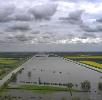
If you are regularly driving down the A10 between Ely and King’s Lynn, you may well have noticed, between Hilgay and Denver, a large sign next to a stream notifying that you are crossing the Cut Off Channel.

Have you ever wondered, like me, what’s the story of this relatively wide piece of water? Well, search no more, because here we will be lifting some of the mysteries.

Sign along A10, just north of Hilgay, when crossing the cut-off channel. Source: Google maps.

Sign along A10, just north of Hilgay, when crossing the Cut Off Channel. Source: Google maps.

In fact, the below information has been kindly supplied by Chris Holley, a Stretham-based local historian, who for many years has been researching engineering and other fascinating features in the Fen landscape. A few years back he wrote a substantial report just about the Cut Off Channel, from which the below information has been obtained. He provided me with a copy earlier this year, which has helped me to understand the history and functions of this intriguing canal.

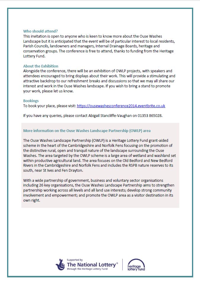
Aftermath of the 1947 floods

A detailed study of drainage problems and ongoing flooding incidents in the Fens was carried out after a series of bad floods in 1936, 1937 and again in 1939, the Sir Murdoch MacDonald Report on Flood Protection published in 1940. Investment in flood prevention was, however, delayed by the Second World War. Following the very bad floods of March 1947 the MacDonald report was reactivated.

Vermuyden’s unbuilt solution

Cornelius Vermuyden, portrait, photo credit Valence House Museum. Source: http://www.bbc.co.uk/arts/yourpaintings/paintings/sir-cornelius-vermuyden-15951677-133559

Cornelius Vermuyden, portrait, photo credit Valence House Museum. Source: http://www.bbc.co.uk/arts/yourpaintings/paintings/sir-cornelius-vermuyden-15951677-133559

Despite Vermuyden’s 17th century large-scale drainage works, the Fens failed to remain dry, with bad flooding episodes happening regularly. This was not Vermuyden’s fault, since one of his proposals had simply never been built.  His drainage map, published in 1642, clearly shows a planned catchwater channel to collect flood waters from three rivers to the east of the Fens (the then-called Mildenhall, Brandon and Stoke Rivers) and divert them via a relief channel to north of his planned Denver Sluice.

The 1940 MacDonald report recommended building just such a cut off channel, collecting water from the same three rivers, now named the Lark, Little Ouse and Wissey.

A map from Cornelius Vermuyden, from his 1642 'Discourse Touching the Drayning of the Great Fennes'; Folger Shakespeare Library, Washington DC. Source: http://www.dbnl.org/tekst/_low001200301_01/_low001200301_01_0016.php

A map from Cornelius Vermuyden, from his 1642 ‘Discourse Touching the Drayning of the Great Fennes’; Folger Shakespeare Library, Washington DC. Source: http://www.dbnl.org/tekst/_low001200301_01/_low001200301_01_0016.php. The red arrow indicated Vermuyden’s proposed ‘cut off channel’. Note that north is to the right on this map.

In addition, this report also recommended building a new Relief Channel to take their surplus flood water away from the Fens and up to Kings Lynn, as well as improving the existing Ten Mile and Ely Great Ouse rivers from Denver to south of Ely.  Work on all three flood defence elements started in 1954 and finished ten years later, in 1964.

The Cut Off Channel’s functions

In short, the Cut-off channel was built to serve two functions:

  1. To relieve the River Great Ouse from the threat of rising floodwater
  2. To deliver excess water to reservoirs in Essex
Taken together, the two different uses of the Cut Off Channel serve to both keep Ely dry in winter and keep Essex wet in summer. Water flows northwards to prevent flooding during winter times, and flows southwards in summer times to deliver water in Essex.
Some amazing engineering has gone into ensuring that both functions can be carried out. The channel runs across 35 miles of fenland from Downham Market to Mildenhall, with numerous sluices along the way. The southern part also goes largely underground before arriving in Essex.

Great Ouse Cut Off Channel: northwards flow for Ouse flood protection

Since it is estimated that 40% of flood waters in the Fens come from the three eastern rivers (the Lark, Little Ouse and Wissey), the importance of the cut off channel for flood prevention becomes clear.

map showing cut off channel

Map showing the Cut Off Channel, in relation to the Great Ouse and its tributaries, the Lark, Little Ouse and Wissey. Source: report Chris Holley, 2005.

When the Great Ouse Cut Off Channel is flowing northwards for Ouse Flood Protection, the water flows starts at the Lark Head Sluice on the River Lark at Barton Mills, when the sluice is opened.  There are four weirs to control the water levels during the considerable fall between the Lark at Barton Mills and the Little Ouse at Hockwold.

River Wissey

At Stoke Ferry, the River Wissey flows in an aqueduct over the Cut Off Channel. Image by Chris Holley.

The Cut Off Channel then flows northwards and intersects the River Little Ouse at the Hockwold Sluice at Hockwold, and then intersects the River Wissey at the Wissey Sluice at Stoke Ferry, and thence to Denver Sluice.

Cut off Channel seen from A10, flowing west towards the Denver Sluice. Photo by Chris Holley

Cut off Channel seen from A10, flowing west towards the Denver Sluice. Photo by Chris Holley

At each of these intersections, the Cut Off Channel goes underneath the Little Ouse and Wissey rivers in a siphon or U-tube, and can draw water from the two rivers when the appropriate sluice gates are opened and closed.

The Relief Channel starts at Denver and takes water from the Cut Off Channel through the Impounding Sluice, and/or from the Ely Ouse through the A G Wright Sluice, down to the Tail Sluice at Saddle Bow near Kings Lynn.  The Relief Channel acts as an
additional flood water storage reservoir, which can be evacuated out to sea at
low tide.

Cut Off Channel

Section of the OS map showing where the Cut Off Channel joins other waterways at the Denver Sluice complex. Source: report by Chris Holley.

Denver Complex 2

Close-up of Denver Sluice complex, showing the various waterways coming together at this important node. Source: report by Chris Holley.

Great Ouse Cut Off channel: southwards flow for Ouse-to-Essex water transfer

Essex regularly suffers from droughts in summer. In 1964 it was realised there was insufficient water to support expansion, development and growing consumer demand in south Essex.  In 1968 it was proposed to reverse the flow and use part of the Cut Off Channel to take surplus fresh water southwards from the Great Ouse at Denver Sluice and  deliver it down to existing reservoirs in Essex.

The Ely Ouse To Essex Water Transfer Scheme was completed in 1971, taking water down to Abberton Reservoir 87 miles south, and to Hanningfield Reservoir 90 miles south.  Although existing watercourses are utilised for about two-thirds of the distance, a new tunnel and new pipelines and storage tanks all had to be built.

When the flow of the Cut Off Channel is reversed southwards for Ouse To Essex Water Transfer, water is diverted through the Diversion Sluice at Denver and flows up the Cut Off Channel, through the siphon under the River Wissey at Stoke Ferry, to Blackdyke Intake at Feltwell, between Stoke Ferry and Hockwold.

Black Dyke intake

Representation showing the physical layout of the shaft at Blackdyke Intake, the tunnel, and the uptake shaft at Kennett Pumping Station. Source: report by Chris Holley.

Water is extracted from the Cut Off Channel at Blackdyke Intake, where it plunges 90 feet down a huge shaft into a long tunnel under the hills and under the A11 near Newmarket, to Kennett Pumping Station.  At Kennett, water is pumped 280 feet up to the surface again, then by pipeline under the hills by the A14 to Kirtling Green Outfall and Kirtling Brook, where it joins the River Stour to Wixoe Pumping Station near Haverhill. From Wixoe Pumping Station, water flows by various means to three Essex reservoirs.

Want to know more?

If you would like to know more about the history of and engineering works along the Cut Off Channel, Chris Holley has produced a richly illustrated and detailed 92-page report, titled ‘Ely Dry – Essex Wet: the Great Ouse Cut Off Channel’. You can contact him for more information, or to purchase a copy through chrishcs@btinternet.com

A synopsis of Chris’ report can also be downloaded here: Cut Off Channel Synopsis 2

Interpretation board at the Denver Sluice, explaining the origin and function of the Cut off channel

Interpretation board at the Denver Sluice, explaining the origin and function of the Cut off channel. Image by Chris Holley.