 My name is Anna Growns and, like Peter Stroud (see here for his previous post) I am also working as a summer placement volunteer for the Ouse Washes Landscape Partnership Scheme. Now in my second week I think I can safely say that I am beginning to get a feel for it all! The scheme brings together a wide variety of projects, and it is fascinating learning more about what makes the Ouse Washes such a unique landscape. There is so much to find out, and I am becoming aware of how little I really know about the area where I live – my reading list grows by the day!
I am currently focusing on water management in the area, which is of particular interest to me as I am hoping to work towards a career in flood risk management. On Monday I visited the Denver Sluice Complex. The morning started with a talk given by Dan Pollard, who works for the Environment Agency, based at the Denver Sluice Complex. His job involves monitoring river levels and adjusting the sluices accordingly. I also met John Martin, a local farmer who owns land immediately adjacent to the Ouse Washes. He was involved in both the 1987 refurbishment of the Denver Sluice, and the Welmore Lake Sluice (which is now also known as the John Martin Sluice).
It was interesting to hear about the potential conflicts between those who use the area; farmers, conservationists, anglers and boaters, amongst others. I will discuss these issues in more detail at a later date, but for now all I’ll add is that there is no perfect solution to managing the area, but perhaps by working together to understand the problems, a fairer outcome could be achieved.

Dan Pollard (Environment Agency) explaining the complexity of managing the Denver Sluice Complex and its many waterways.
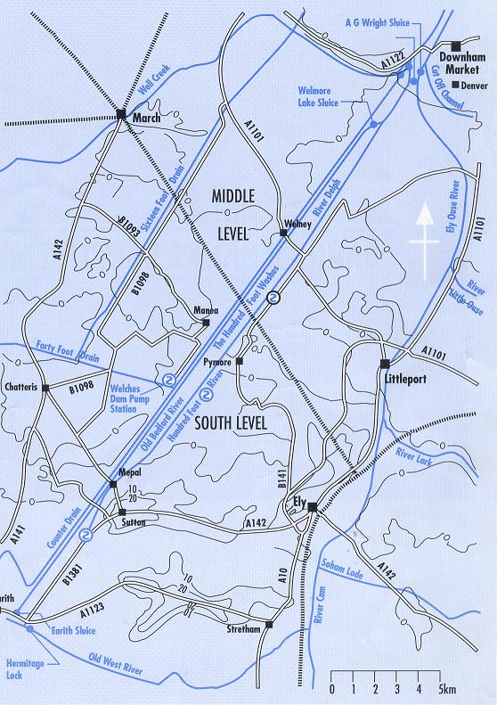
Anyway, I mustn’t get side-tracked – back to Denver Sluices! Denver Sluice is just one of several in the area that make up the Denver Sluice Complex. They play a vital role in controlling river levels, and are successful in stopping the low-lying fenland from flooding. I suppose before discussing the sluices it makes sense to begin with a wider look at the function of the Ouse Washes. The diagram below shows the area from Earith in the south to Downham Market in the north. The Ouse Washes lie between the New Bedford River to the east, and the Old Bedford/River Delph to the west. As previously mentioned in this post, these channels were created as part of Vermuyden’s scheme to drain the fens.

Ouse Washes overview: geography and names of main channels. Source: http://www.ousewashes.info/maps/washes-lrg.jpg
The first channel, the Old Bedford River, was cut in 1630, and the second, the New Bedford River or Hundred Foot Drain, was constructed 20 years later. As can be seen from the diagram, this considerably shortens the route that water takes from Earith to Downham Market on its journey to the sea (where previously the water would have followed the course of the Great Ouse River to the east), thereby diverting water from the surrounding fenland and discharging it more quickly.
The purpose of having two parallel channels was to create a huge flood storage area, i.e. the Ouse Washes, which protects the surrounding land from flooding. To put it very simply, when there is too much water in the River Great Ouse the water is allowed to flow onto the washes, normally through the Earith Sluice and the Old Bedford River, and stored there until it can be discharged. The following diagram explains in more detail how this works (see also this previous post):

Schematic layout of the Ouse Washes flood system. It also shows the relatively few crossings over the washes. Source: Environment Agency and http://www.ousewashes.info. Click on the map to enlarge.
Next time I will look in more detail at particular aspects of how this system works. More information on water management in the Ouse Washes can be found at the following useful websites: ousewashes.org and ousewashes.info
